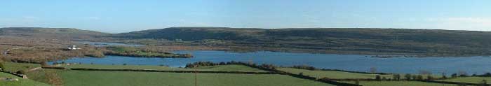
Carron Polje and Turlough – Geosite
A Polje is a large flat-bottomed valley feature of limestone regions formed by prolonged dissolution. The Carron depression can be classified as a Polje. The Carron Polje is the largest enclosed depression in Ireland with an area of approx 4.5km2
The depression began forming several millions of years ago when overlying shale layers were eroded and rainwater began the slow process of dissolving the underlying limestone. As erosion continued and the depression grew, insoluble components of the limestone accumulated and formed an impermeable layer over the limestone, this prevented further downward dissolution and encouraged the lateral widening of the depression giving us the flat-bottomed feature we see today.

Disappearing Lake
The disappearing lake or Turlough is the most obvious part of the Polje. After significant rainfall the bottom of the valley fills with water to form a lake. The only outlet to drain the water is through a small natural karst fissure in the limestone at the southern margin of the lake. This can get blocked by mud or other debris and drains slowly. If there is no significant rainfall the water will drain and the lake will disappear only to fill again after more rain. During dry periods the lake floor is grazed by cattle.
Underground rivers
Despite the relatively high amount of rainfall (>1000mm per year) there is only one small surface river in the Burren. This is because soil is very thin or absent and the limestone has been karstified, so deep fissures carry the surface water underground very quickly. These fissures form a complex network and sometimes form conduits that can transport water long distances very quickly. The water that flows underground from the end of the Carron Tulough is known to emerge 6km to the south near Kilnaboy. This makes the Burrren particularly vulnerable to water pollution.