Geohazards in the Burren and Cliffs of Moher UNESCO Global Geopark
Geohazards include earthquakes, volcanic eruptions, landslides, tsunamis, floods, meteorite or asteroid impact, coastal erosion and can range in impact from local events that a minor inconvenience to events that could threaten the existence of humans (asteroid impact). In the Burren and Cliffs of Moher UNESCO Global Geopark we recognize four potential geohazard risks that could affect us:
1. Tsunami
A series of large waves generated in the sea by either earthquake, volcanic activity or large landslide that can travel huge distances and travel for inland in low-lying areas.
It might surprise you to see tsunami listed as the first geohazard, as we are not in a tectonically active area, however we know from the past that we have been affected by tsunamis and there is good evidence to suggest that we are still at risk from tsunamis. In 1755 an earthquake off the coast of Lisbon, Portugal triggered a tsunami. The resulting tsunami waves travelled north and struck the south and western coast of Ireland. There is a local story that the tsunami separated Aughinish Island from the Flaggy Shore in the very north coast of County Clare. A recent study commissioned by Geological Survey Ireland has shown that the waves that struck Galway Bay would have been about 2 m high and would have inundated areas along the coast. If the tsunami occurred at a high spring tide the combined effect would have been more significant.
Geological Survey Ireland is the national contact point for the UNESCI/IOC tsunami Early Warning and Mitigation System in the northeast Atlantic, the Mediterranean and connected sea. Geological Survey Ireland installed a tsunami sea level gauge on Inishmore (Galway Bay) in 2019. Other national partners such as Dublin Institute of Advanced Studies (DIAS) monitor seismic activity and Met Eireann are notified by French and Portuguese tsunami warning centres.
So, while it has been a few hundred years since the last tsunami affected Ireland, we cannot say when the next one might happen. It may come from earthquake activity off Portugal again as they are in a tectonically active area due to the pressure of the African continent colliding with the European continent or perhaps from a major landslide far offshore along the continental slope or perhaps a volcanic eruption in the Azores or Canary Islands. In any event, when you are enjoying the coast, please always pay attention to the sea because even in good weather, with no tsunami, isolated rogue waves can strike without warning.

Photo Credit to Geological Survey of Ireland Marine and Coastal Unit
2. Flooding
Flooding happens when more rain falls than can drain away through rivers or drains. This can happen because of short intense rainfall events or longer less intense but continuous rainfall events. In the Burren we only have two surface rivers; the Aille/Gowlaun River (Lisdoonvarna/Doolin area) and the Caher River (Fanore area), most of the water that falls ends up draining underground very quickly through the cracks and fissures in the bare limestone. The lack of soil cover and vast amount of cracks and fissures means the rain gets underground very quickly, it also means that narrow conduits underground can fill extremely quickly in which case the water will emerge on the surface and cause flooding. Turloughs such as the Carron Turlough are perfect examples of this, when the underground system is full the temporary lake fills and then drains slowly when the rain stops. As we know about the turloughs they fill and drain without affecting much, it is usually only when floods spill out onto roads or flood houses that they are considered a geohazard.

Flooding in County Clare
3. Landslides
Landslides or rockfalls can happen anytime a surface is unstable, either because the slope has oversteepened and is not supported or because the supporting base has been removed by man or nature. Most landslides in the Geopark are considered rockfalls and happen along the coast, minor rockfalls are common all along the Cliffs of Moher (please stay back from the edge). Another type are called bogslides, this happens when saturated bogs become detached from the underlying bedrock and slide down even very gentle slopes. We have elevated bogs on top of Slieve Elva, Knockauns and Poulacapple however there are no records of bogslides in these areas but with increased rainfall due to climate change and relatively recent human activity (forestry plantation and forest tracks) it should be noted that bogslides are a risk in these areas. With a very low population density in these areas the risk to humans is low, but real.
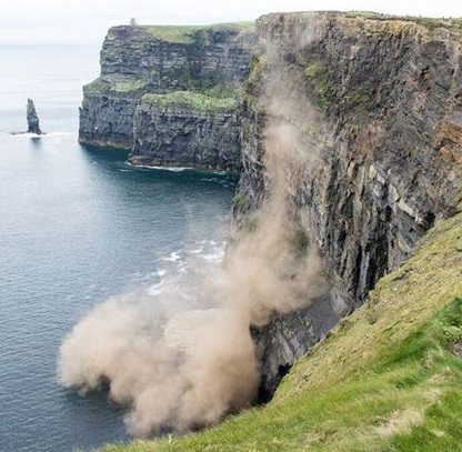
Rocks falling from the face of the Cliffs of Moher
4. Earthquakes
While we are located far from tectonically active areas (the closest active areas are the mid Atlantic or the Mediterranean) we do very occasionally have Earthquakes. The most recent was Thursday 6th May 2010 at 10.24pm. It measured 2.7 on the Richter scale so was only a minor event. It was felt around the Doolin area with many people reporting a sound like’ rolling thunder’ or a ‘gas tank exploding’. There were no reports of damage to property. Even minor earthquakes such as this are very rare here, with this the only known record in north Clare. If we are not in an active tectonic area what caused the earthquake? It is difficult to say but was probably a result of isostatic re-adjustment. During the ice age (20,000 years ago) there were massive ice sheets covering the Burren (and all of Ireland). The weight of these pressed down on the Earth’s crust and caused compression. After the ice melted (around 17,000 years ago) that pressure was released, and the crust began to decompress, to re-adjust. This process can cause minor earthquakes as the stress accumulated in the rock is released very slowly over time. This type of earthquake is more common in northern Europe where the ice lasted much longer and re-adjustment is still happening. As the crust under the Baltic sea expands again the land is rising slowly and the Baltic sea is draining slowly. It may be a very long time before we experience another minor earthquake here in the Burren and Cliffs of Moher UNESCO Global Geopark and although coastal cliffs may have rockfalls, we do not expect any significant hazard from any future earthquakes here.
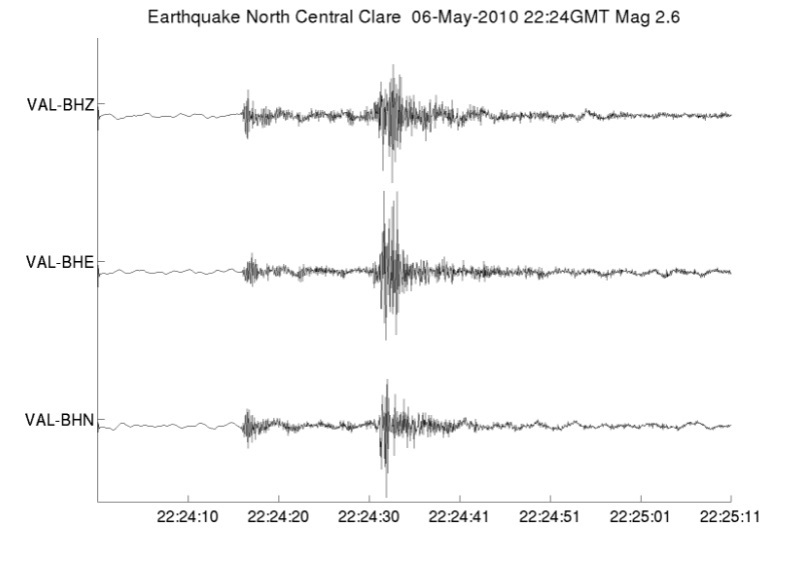
Earthquake measurement in North Clare from 2010